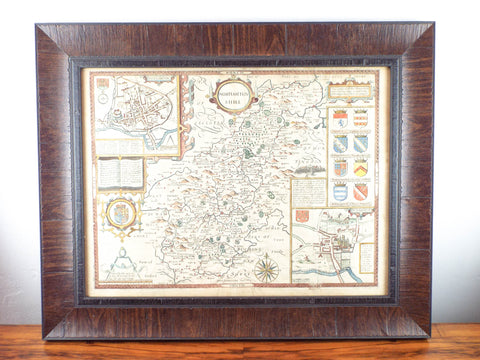


Framed Antique 17th C Hand Color Map Of Northamptonshire
Original antique 17th century hand colored map of Northamptonshire and its surrounding counties which was printed and published by John Speed in his famous Theatre of the Empire of Great Britaine. Dated for 1611 as a publishing date by Jodocus Hondius the inset town plans of Peterborough and Northampton are the earliest known of these places. On the reverse of the map there is a complete set of text briefly describing the history and topography of the county. The aesthetic beauty of the maps were done by the Dutch engraver, Jodocus Hondius, whose fine calligraphy and decorative strapwork are a feature throughout.
A great addition to any rare map collection.
MEASUREMENTS
Framed map measures 22" wide by 16.5" tall and weighs 6lb 12oz.
CONDITION
In good condition and ready to hang (please see all pictures as they form part of the condition description).
Click Here to see our shipping, returns and refunds policy
Feel free to contact us if you have any further questions about this item.
We Also Recommend


